Article Title :
Spatial Characteristics of the Southern Al Jabal Al Akhdar Watersheds: Remote Sensing Approach
3 (2019)
37-48
Wadis , spatial analysis , Remote Sensing , GIS , Libya


The present study is to evaluate the spatial characteristics of the watersheds located in Northeast Libya, which is vital since the area is promising for surface water investment in rain-fed agriculture and pastoral activities. The study conducted using Geographical Information System (GIS) and Remote Sensing (RS) data sets: SRTM elevation data, Landsat 8 (OLI) imagery and Global Climate Monitor (GCM) data. SRTM data processed in ArcGIS, where elevations show a progressive decrease towards the South and eleven watersheds delineated (17721km2). Moreover, the perimeter, slope, aspect, and stream length of the watersheds also calculated. The hydrologic divide bounds the watersheds in the North delineated; it extends from the Southwest to the East with a length of 470km. Also, the outlets of the watersheds, which are mostly temporary lakes, those locally known as Balat assessed spatially. Landsat 8 imagery classified by Quantum GIS (QGIS), where five classes identified (alluvial plains, spreading zones, forest, grassland and bare rocks). Furthermore, precipitation and temperature data from the GCM was mapped, where the precipitation shows the highest rates in the North and gradual decrease to the South, unlike the temperature values indicate an increase towards the South and drop in the North.
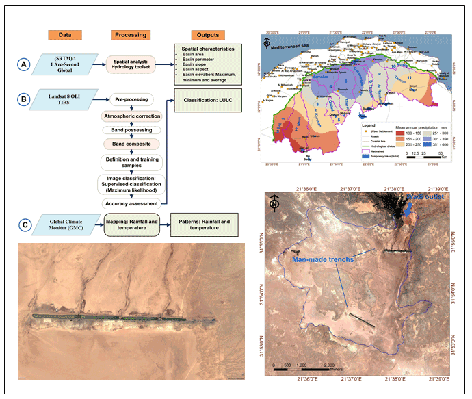
Spatial characteristics of the watersheds located in Northeast Libya were analyzed in the study.
The seasonal runoff in the wadis during the rainy seasons is the surface water resource in the study area.
The outlets of the wadis mostly in the temporary lakes are topographically flat depressions located downstream.
Remote Sensing (RS) data sets: SRTM elevation data, Landsat 8 (OLI) imagery and Global Climate Monitor (GCM) data were used for the analysis.
Five land use land cover classes: alluvial plains, spreading zones, forest, Grassland and bare rock area were identified.
Arghin, S. S., 1980. Hydrogeology of El Marj basin. MSc Thesis University of Nevada Reno USA.
Arlab Consulting Engineers, 1982. Supervision of drilling water wells in South Al Jabal Al Akhdar Area. Executive Authority of Al Jabal Al Akhadr-Libya. Unpublished report.
C-Louti (Italian consultant), 1977. Soil investigation and irrigation network design in South Al jabal Al Akhdar Area. Executive Authority of Al Jabal Al Akhadr-Libya. Unpublished report.
Franlab (French consultant), 1974. Water resource study of the Southern Flank of Al Jabal Al Akhdar., Phase I. Executive Authority of Al Jabal Al Akhadr-Libya. Unpublished report.
Franlab (French consultant), 1978. Water resource study of the Southern Flank of Al Jabal Al Akhdar., Phase II, Executive Authority of Al Jabal Al Akhadr –Libya. Unpublished report.
GCM [Global Climate Monitor], 2019. Climate Research Group. University of Seville.
GWA [General Water Authority] Libya, 2006. Water Statues of East Libya.
Hamad, M. S., 2005. Delineation of South Al Jabal Al Akhdar CatcmentArea. General Water Authority. Unplished report.
Hamad, M. S., 2008. Spatial analysis and interpretation of groundwater levels and hydrochemistry in south Al Jabal Al Akhdar. Master thesis. Salzburg University- Austria.
IRC [Industrial Research Center], 1974. Startigraphic Lexicon of Libya, 300.
Pallas, 1980. Water resources of the socialist people’s Libyan Arab Jamahiriya. The geology of Libya-second symposium on the geology of Libya, held at Tripoli, September (12-16), 1978, 539-593, Academic Press.
Singh, V. P., 1994. Elementary Hydrology. Prentice Hall of India Private Limited, 377-406.
SWECO, 1986. Land Mapping and Pasture Survey of the South Al Jabal Al Akhdar area, South Al Jabal Project (SJP). Unpublished report.