Article Title :
Multi-Criteria Decision Making for Vulnerability Mapping of Flood Hazard: A Case Study of Pune City
2 (2018)
41-52
Pune , Vulnerability , Urban , Remote Sensing , Multi-Criteria Decision Making , GIS , Flood , Hazard


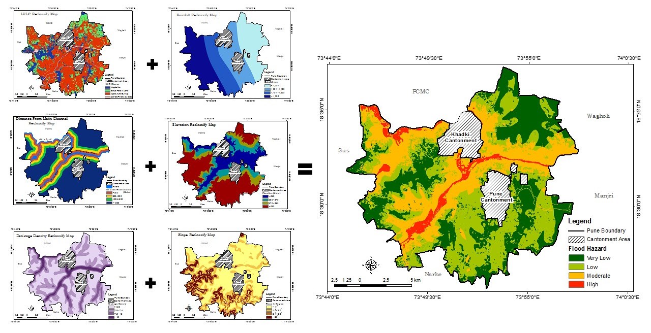
Floods are natural risk with a very high frequency, which causes to environmental, social, economic and human losses. The floods in the town happen mainly due to human made activities about the blockage of natural drainage, haphazard construction of roads, building, and high rainfall intensity. Detailed maps showing flood vulnerability areas are helpful in management of flood hazards. Therefore, present research focused on identifying flood vulnerability zones in the Pune City using multi-criteria decision-making approach in Geographical Information System (GIS) and inputs from remotely sensed imageries. Other input data considered for preparing base maps are census details, City maps, and fieldworks. The Pune City classified into four flood vulnerability classes essential for flood risk management. About 5 per cent area shows high vulnerability for floods in localities namely Wakdewadi, some part of the Shivajinagar, Sangamwadi, Aundh, and Baner with high risk.
Multi-criteria analysis is effective geospatial techniques for identifying the flood vulnerability zones and disaster risk reduction in Pune city.
Six major criterion are considered for mapping of flood vulnerability: land use/ land cover, distance from channel, drainage density, rainfall, elevation, and slope.
The weights for criterion are assigned based on expert’s opinion and previous case studies.
The flood vulnerability is classified into four classes: very low, low, moderate and high flood risk.
About 5% of study areas shows higher vulnerability for floods in Pune City.
Census of India, 2011. Government of India.
Congalton, R. and Green, K., 2008. Assessing the Accuracy of Remotely Sensed Data: Principles and Practices. Second Edition, CRC Press, Boca Raton.
Isma’il, M. and Saanyol, I. O., 2013. Application of remote sensing and geographic information systems in flood vulnerability mapping: Case study of River Kaduna. International Journal of Geomatics and Geosciences, 3(3), 618-627.
Jensen, J. R., 2004. Remote Sensing of the Environment: An Earth Resource Perspective, University of South California.
Malczewski, J., 1999. Spatial multicriteria decision analysis. In: J.-C.Thill (ed.), Multicriteria decision making and analysis: a geographic information sciences approach, Brookfield,VT; Ashgate Publishing, 11-48.
Mundhe, N., Deshmukh S., and Vyas A., 2017. GIS based urban flood vulnerability analysis in Western Zone of Ahmedabad City. International Journal of Research in Geography (IJRG), 3(4), 41-51.
Saaty, T. L., 1980. The Analytic Hierarchy Process, McGraw-Hill, New York, 20-25.
Sawant, S. B., 1978. The City of Poona, A Study in Urban Geography, Poona University Publication.