In this era of climate change induced frequent flooding, proper management of flood events are assuming greater importance with each day for government authorities. As far as the better flood management is a concern, there is an increasing trend towards to adopt the non-structural approach which is less costly and more effective in comparison with structural measures. The latest technical tools such as GIS incorporated with super computer systems have come with a real boon towards better flood management for government administration. In order to explore the best capabilities of such kind of integrated systems for better flood management, an Integrated Flood Management System (IFMS) is proposed in this writing incorporating GIS and super computer platform. This system illustrates the functional utilities such as flood situation monitoring, damage estimation and analysis, decision support system and finally the action plan development for better flood management. This system will allow taking inputs from both spatial and non-spatial data including physical, socio-economic and socio-cultural data, flood-related data pertaining to the district and taluka. This study has also proposed the steps of action plan development through the integrated system at the administrative and individual level.
Keywords
1 . INTRODUCTION
Among all other Asian countries, India is highly sensitive to frequent flooding events. According to National Commission on Floods assessed that the flood-prone areas in India are increasing over time. States like Orissa, Bihar, West-Bengal, Assam, Jammu and Kashmir, Tamil Nadu was experienced severities of many flooding events in recent time which causing huge damage and destruction to the local population and their properties. To tackle with such threat, till now there is no such strong management nor any standard system being adopted due to the various nature of these flooding events at district and taluka level in all over the country (Singh and Ballabh, 2011). In this recent era, the advancement of spatial and computer technology, it becomes very easy to face and fight with such menaces (Sutanta et al., 2009). Appropriate action and planning through providing infrastructure facilities, amenities, manpower, relief and rescue operations, deployment and control of the rescue boats and relief administration have become easier for the soldiers of the district and taluka administration by utilizing the capabilities of integrated GIS and computer technology. In this study, we introduce GIS-based ‘Integrated Flood Management System’ (IFMS) which is containing both spatial and non-spatial data for district and taluka administration with the motivation of better flood management and mitigation. This study will enable the district and taluka authorities to function more effectively in monitoring flood situations and administrating timely rescue and relief activities during critical flood conditions.
2 . IFMS SYSTEM
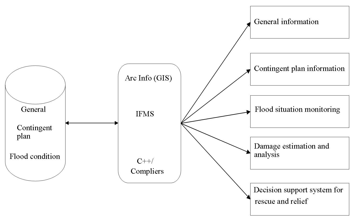
IFMS system can be developed on powerful computer platform using Arc Info (GIS) and C/C++ language. The prime functionalities of IFMS system are:
2.1 General Information
This is the very basic level of information which includes various physical, administrative and socio-cultural data obtained from district and taluka level. It is well observed that this kind of general datasets like topography, drainage, population, socio-economic conditions though have nothing to do with the disaster but these are playing the crucial role to the administrative level during pre and post-disaster circumstances. So, in this concern, IFMS attempts to stock all important data including both the spatial and non-spatial and make it available to the user during requirement. The main data stored in the IFMS are:
2.1.1 Physical Data
Topography
Hydrology
Weather and climate
Drainage
Vegetation cover
Soil
2.1.2 Administrative Data
Political and administrative boundaries of District and Taluka
2.1.3 Socio-cultural Data
Population
Infrastructure
Land use
Socio-economic conditions
2.1.4 Flood Data
Post flood data
Real-time flood data
Figure 1. IFMS system
2.2 Contingent Plan Information
Normally every flood prone district administration pre-developed a contingent plan in order to tackle sudden flood situations. Access to such plans is very vital during the time of flood especially, when flood is in its advancement. This kind of information is very useful when it available in a spatial map based format because it enables the district and taluka administration to view and observe the inundation dimension of the flood and also incorporates with other relevant spatial information.
In broad sense contingent plan information included in IFMS are:
Past contingent plan and damage information
Latest contingent plan
Administrative information
Available resource and facilities
Vulnerable / Weak points
Alternative communication routes
2.3 Monitoring of the Flood Situation
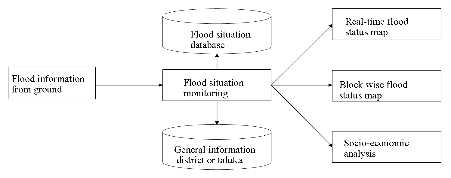
In the time of flood, it is essential to understand the current flood situations flowing to the district and taluka level from many field informers through the government officials and should be aware of its destructive potentiality arising out from the flood conditions. This is only possible digitally at your single eye glance and interpreted on a base map of the affected region along with other thematic attributes. It also estimates the approximate damage through the utilization of the suitable GIS software packages like ArcGIS.
Figure 2. Flood situation monitoring
IFMS will allow you to handle such kind of available data like, the flood situation information covering the damage, rescue and relief with provided facilities to view such information in conjunction with other cultural information i.e. population, settlement, infrastructures (Roads, Railways, etc.) and other socio-economic data pertaining to the area of concern. In addition to that, necessary models are also available to estimate the damage based on the actual inundation or predicted inundation map.
The detailed flood situation data incorporates with affected sites, causalities, damage to public and private properties, measures on health and veterinary, relief and rescue operations.
2.4 Estimation of Damage and Interpretation
It is usually seen that even government and NGOs are well equipped with the all flood information and data. But they are not able to scientifically estimate and analyze potential damages and impacts because manually it is not possible to translate the situation information in terms of its quantitative impact.
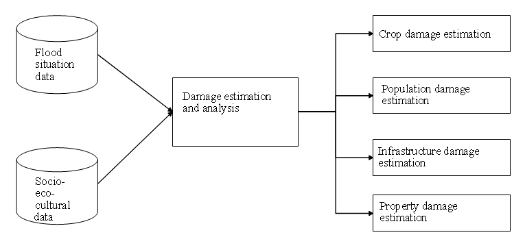
Figure 3. Damage estimation and analysis
IFMS solves this problem by making the extensive involvement of the socio-economic and socio-cultural data along with other flood situation information through the necessary application program. It also allows you to predict the estimated future damages through the upgraded software applications in terms of both spatial and non-spatial data.
2.5 Decision Support System (DSS) for Relief and Rescue
Undoubtedly this is the most vital part of the better flood management which includes the timely and effective rescue and relief administration and operations to the victimized or probably victimized zones by the flood hazard. Inefficient or inappropriate management gives authority a serious repercussion in the terms of massive and unexpected loss to the life and property.
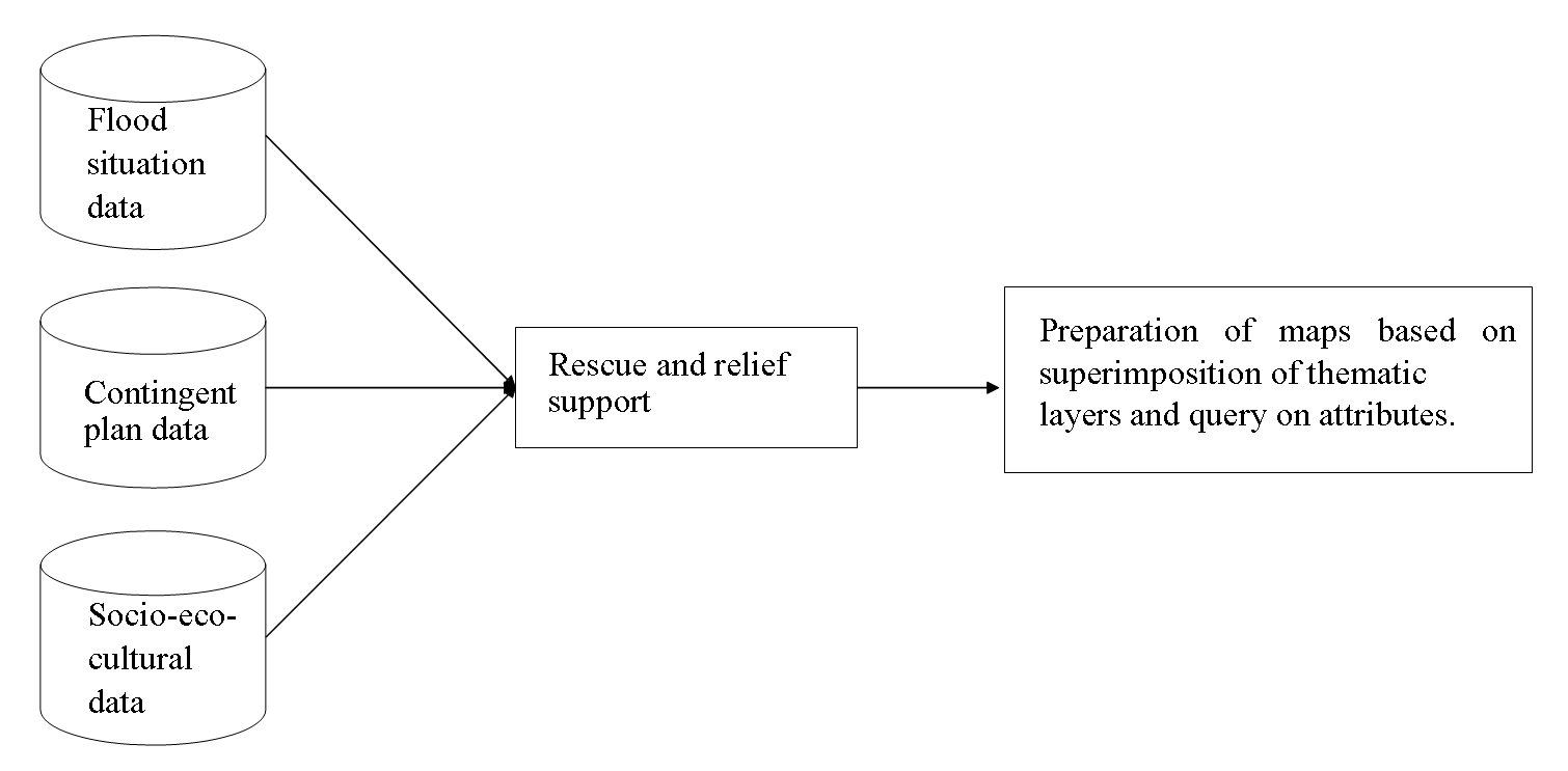
Figure 4. Decision support system
In IFMS platform the decision support system will provide the facilities to the district and taluka administration by giving them necessary functionalities to superimpose the multiple related information on flood situation, general information and contingent plan information. Hence the latest flood situation can be viewed and monitor along with the information about existing infrastructures and other facilities from general and contingency plan database. Thus, it is easier to take the further decision regarding rescue relief and action plans. It will also enable to develop a readymade DSS framework to fight against the flood catastrophe.
3 . DEVELOPMENT OF ACTION PLAN
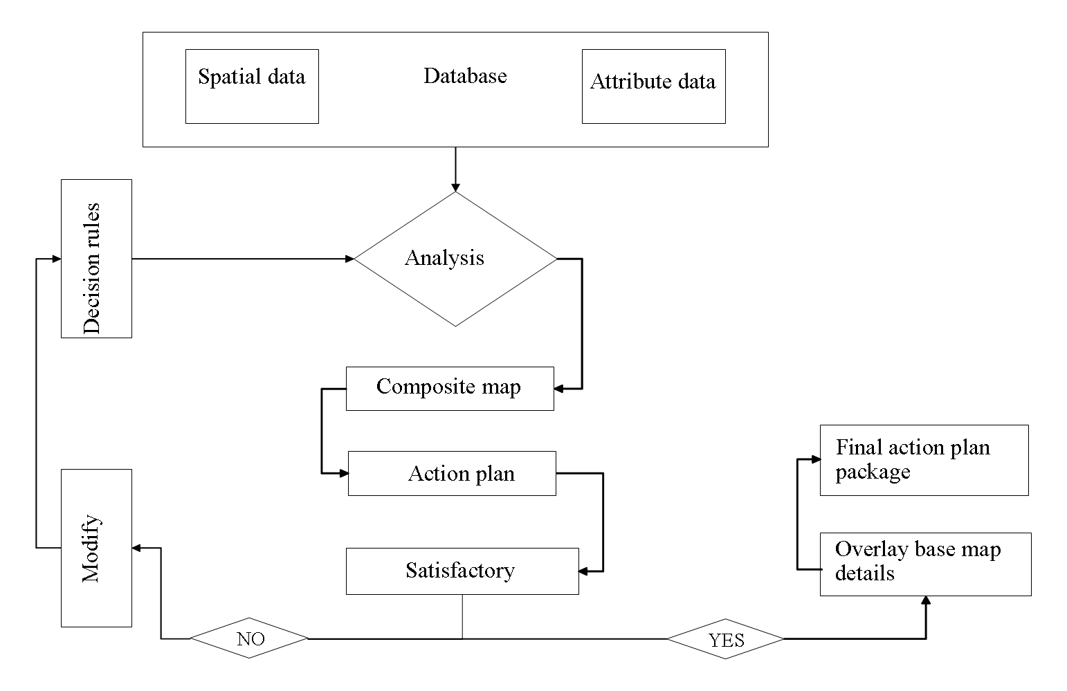
Finally, IFMS will allow you to develop the final action plan based on the decision taken through the previous step. Now days the forecasting and early warning systems are highly advanced and enriched to protect the human lives and property from hazards and disasters. But sometimes due to the technical or other failures, these systems are not working as per the expectations. On that time this is highly necessary to develop a strong action plan to rescue and provide relief to the victimized population from the devastating situations. IFMS will deliver a strong mapping and action plans which provide an effective summary of the information added. This is useful in determining the optimum use of the available resources for the benefit of the community. Integrated information data, receives a set of decision rules and finally use them to analyze the integrated layer and build an adaptive action plan package.
4 . INDIVIDUAL LEVEL ACTION PLAN
Sometimes government promotes capacity building and training program at the individual level to make the individual resilient at his/her own level (Tadele and Manyena, 2009). It will also enable the human capability to fight against natural calamities like flood. The individual level action plan incorporates:
Prepare to relocate
Review your emergency kit
Preparing pets and livestock
Quick household tips for the basic amenities like electricity, gas, water, etc.
Help to the old people
Figure 5. Action plan
5 . IMPLEMENTATION OF ‘RADAR DATA’ FOR REAL-TIME FLOOD INFORMATION
Remote sensing is the most practical and realistic method available to managers of flood-prone areas for quantifying and mapping flood impacts (Hoque et al., 2011). There are number of sensors and data processing techniques are available in present to extract the information about floods. The instruments that record flood events may operate in the visible, thermal, or microwave range of electromagnetic spectrum. But due to the limitations posed by adverse weather conditions and cloud coverage during heavy rainfall and flood events, active radar (SAR and altimetry) is invaluable for monitoring floods (Schumann, 2015). According to Kuenzer et al., (2013) microwave sensors are especially appropriate instruments, as they allow the differentiation of inundated from non-inundated areas, regardless of levels of solar illumination or frequency of cloud cover in regions experiencing substantial rainy seasons (Kuenzer et al., 2013). Microwave data not only providing the direct information about flood mapping or information but also it can be incorporated with flood models through model calibration, data assimilation techniques. There have been distinguished studies on integrating remotely sensed data both optical and SAR with flood modeling since the late 1990s and there is now a general consensus among space agencies to strengthen the support that satellite missions can offer (Schumann, 2015).
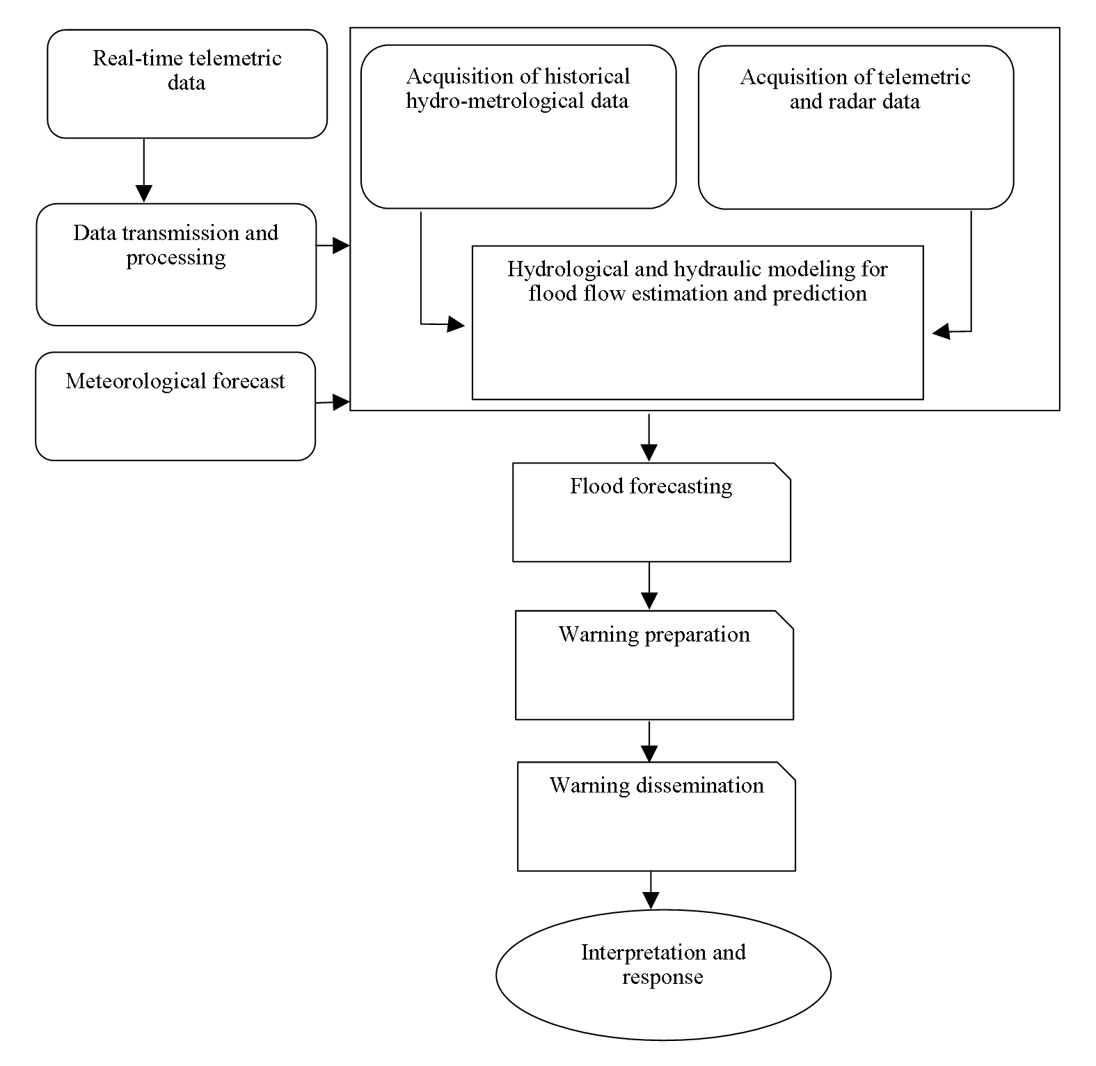
In the United States, Nexrad radar rainfall system provides maps of storm precipitation updated every few minutes. This would be highly significant and beneficiary for public safety viewpoint as these radar rainfall maps can easily be translated into flood inundation map during the storm events. This allows the authority to warn the citizens to stay away from roads and outsides. Being able to create real-time flood inundation maps requires connecting map data on ground conditions with a time sequence of rainfall maps and with flood simulation models to produce a time sequence of flood maps on the ground (Maidment, 2002). In this regard, the ArcHydro toolset can be useful software that can be easily handled by trained government officials. However, there is other open source software like Quantum GIS are also available which is useful for this purpose.
6 . ROLE OF DIGITAL ELEVATION MODELS (DEM) IN FLOOD MODELS
Topography plays an important role in hydrological modeling and in flood mapping. This is a determining controller of the accuracy for hydraulic models and flood inundation maps (Brandt, 2005; Cook and Merwade, 2009). Digital Elevation Model (DEM) is a raster dataset containing information about the topography of a region and is used as a prerequisite to hydraulic modeling. Resolution and accuracy are the two main properties of a DEM that affect the flood maps and flood models (Vaze et al., 2010). The spatial resolution of a DEM refers to the area covered on the ground surface by a single cell which suggests that a higher resolution DEM has more number of cells per unit area and thus represents the topography more accurately as compared to a coarser resolution DEM (ESRI, 2014). Resolutions of DEMs can affect the parameters and attributes derived from them and influence models associated with them (Gallant and Hutchinson, 1997; Omer et al., 2003). The vertical accuracy of a DEM is the probability distribution of digital elevation values measured with respect to the true value. Thus, DEM resolution and accuracy have a significant impact on water surface elevations and flood extents.
DEM obtained from LiDAR data have a high resolution and accuracy and are used extensively for hydraulic modeling and precise flood mapping purposes (Cook and Merwade, 2009; Rayburg et al., 2009). Flood maps obtained on using LiDAR data are more accurate than the other widely used DEMs present in the world (Charlton et al., 2003). Though LiDAR DEMs are the best for flood mapping in the present world have some limitations. Firstly, several areas within the India and across the world, LiDAR data is still unavailable. Secondly, the use of LiDAR data is not feasible for some locations due to time constraints and cost of acquisition. However, in reality, this is quite unaffordable for the local governments to purchase the LiDAR data. Thirdly, the processing of the LiDAR DEM derived flood maps is needed advance remote sensing operations and computational processing which is still absent in the present situations at the local levels. So, in replacement of LiDAR DEM data, the authorities can use freely available Shuttle Radar Topography Mission (SRTM) 1 Arc-Second Global DEM (30 meters), CARTOSAT 1 DEM (2.5 meters), ALOS Global Digital Surface Model (AW3D30) 1 Arc-Second (30 meters). Even the authority can also develop precise DEMs by their own using high-resolution CARTOSAT-1, CARTOSAT-2 data and Ground control points (GCPS) in a photogrammetric platform. This operation can be done in all versions of Leica photogrammetry suites (LPS).
Figure 6. Flood warning system
7 . REAL-TIME FLOOD THROUGH NUMERICAL MODELING
Numerical weather prediction (NWP) models are gaining more and more attention in providing high-resolution rainfall forecasts for real-time flood forecasting (Liu et al., 2015). The weather research and forecasting (WRF) model coupled with probability distribution models and with other statistical models incorporating metrological datasets producing the high level and accurate flood forecasting. But to run this model successfully and to forecast a correct real-time flood event needs super computer systems as well as a strong mathematical expertise. Thus, this is very tough to implement such an environment at local government levels to provide significant flood forecasting. At least for this purpose, we need to depend on research centers and universities.
8 . CONCLUSION
In this era of climate change and related frequent flood events put the government in a big trouble and it is also seriously hampered the national development program and global sustainable goals (Tanner et al., 2009). Developing country like India, where population exploration is a burning issue, saving those population is also a big challenge (Bandopadhyay, 2014). In this situation government and helping NGOs seriously need a strong technical support to make a better flood management to reduce the death and destructions. In this regard, IFMS will help for better flood management practices which will also enrich the technical capabilities of government officials in this phase of digital India initiative. This kind of systems currently being used and implemented by the state government of Orissa for the Cuttack district and the results are highly supportive and satisfactory. So, it is expected that IFMS will give a boost towards better flood management for the district and taluka level administration. Moreover, it would serve as an example for the others to follow. The proposed system can be adopted by other developing nations where frequent flooding due to climate change is a serious issue.
Tables
Figures
Conflict of Interest
The author declares no conflict of interest.
Acknowledgements
The author is thankful to the Indian Institute of Remote Sensing (IIRS) Indian Space Research Organization (ISRO) for supporting work environment. The author also extends his thanks to anonymous reviewers for the valuable comments and suggestions.
References
1.
Bandopadhyay, S., 2014. Role of state disaster management authorities in India, Southasiadisasters.net. Overcoming implementation challenges for the HFA2: New areas, newer insights’, 119, 9-10.