Article Title :
Identifying Most Influential Land Use Parameters Contributing Reduction of Surface Water Bodies in Rajshahi City Bangladesh: A Remote Sensing Approach
2 (2018)
87-95
Rajshahi , Preservation , Urbanization , Change Detection , LULC , Remote Sensing , Water bodies


Surface water bodies are one of the irreplaceable natural resources for human survival, and it extensively reduces with increasing the world population. This study modeled the spatiotemporal changes of land use / land cover (LULC) and identified the most influential LULC parameters, which contributes in the reduction of surface water bodies using the Landsat 4 and 5 TM and Landsat 8 OLI images (1992-2017). Rajshahi City Corporation is situated in the Northern piece of Bangladesh. A maximum likelihood supervised images classification algorithm was used for detection of changes in LULC. Matrix union technique was used for identifying the prominent LULC parameters. About 14% of water bodies were filled up in twenty-five year (1992-2017) due to rapid urbanization in Rajshahi City Corporation area. This study can provide an essential move towards necessary actions for preservation of surface water bodies to maintain the ecological balance and environmental sustainability.
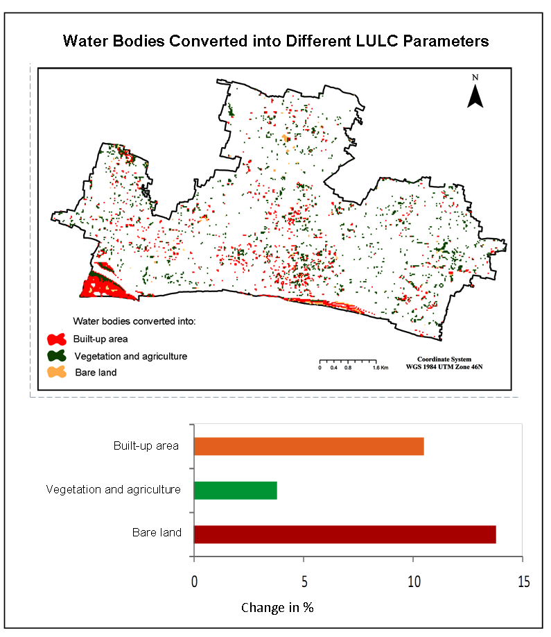
Surface water bodies are reducing at rapid rate in Rajshahi City of Bangladesh.
Remote sensing and GIS technologies were used to estimate the water body reduction.
Around 14% of water bodies were filled up in 25 years due to rapid urbanization in Rajshahi City.
Findings are useful to the policy and decision maker for sustainable surface water management.
Ayub, R. and Miah, M. M., 2011. Effects of change in temperature on reference crop evapotranspiration (ETo) in the northwest region of Bangladesh. Paper presented at the 4th Annual Paper Meet and 1st Civil Engineering Congress, December.
BBS [Bangladesh Bureau of Statistics], 2011. Statistical Yearbook of Bangladesh. Statistics Division, Ministry of Planning, Dhaka, Government of the People’s Republic of Bangladesh.
BBS [Bangladesh Bureau of Statistics], 2013. District Statistics 2013, Rajshahi. Bangladesh Bureau of Statistics.
Clemett, A., Amin, M. M., Ara, S. and Akan, M. M. R., 2006. Background information for Rajshahi City, Bangladesh. WASPA Asia Project Report, 2, 1-29.
Dewan, A. and Corner, R., 2013. Dhaka megacity: Geospatial perspectives on urbanisation, environment and health: Springer Science and Business Media.
Faridatul, I. and Jahan, S., 2014. People’s perception regarding the development of community facilities: A case study of Rajshahi City Corporation. J. Bangladesh Inst. Plan. 7, 1-16.
Goudie, A. S., 2018. Human impact on the natural environment. John Wiley and Sons.
Kafy, A. and Ferdous, L., 2018. Pond Filling Locations Identification Using Landsat-8 Images In Comilla District, Bangladesh. Paper presented at the 1st National Conference on Water Resources Engineering (NCWRE 2018) CUET, Chittagong, Bangladesh.
Kafy, A., Ferdous, L., Faisal, A., Khan, H. and Sheel, P., 2018. Exploring The Association of Surface Water Body Change and Rapid Urbanization in Rajshahi City Corporation (RCC) Area Using RS and GIS. Paper presented at the 1st National Conference on Water Resources Engineering (NCWRE 2018).
Kafy, A., Rahman, M. S., and Ferdous, L., 2017. Exploring the association of land cover change and landslides in the Chittagong hill tracts (CHT): A remote sensing perspective.
Owojori, A., and Xie, H., 2005. Landsat image-based LULC changes of San Antonio, Texas using advanced atmospheric correction and object-oriented image analysis approaches. Paper presented at the 5th international symposium on remote sensing of urban areas, Tempe, AZ.
Rasel, H., Hasan, M., Ahmed, B. and Miah, M., 2015. Assessment of Ground Water fluctuation and Recharge due to rainfall in Barind Area under Greater Rajshahi District (North Western Part of Bangladesh). International Journal of Civil and Environmental Engineering IJCEE-IJENS, 13(02), 15-25.
Sharma, K., 2019. Urbanization induced land use-land cover changes in the Manipur valley and surrounding hills: A landscape metrics approach. Environmental Change in the Himalayan Region, 137-155, Springer.
Zhu, Z., Fu, Y., Woodcock, C. E., Olofsson, P., Vogelmann, J. E., Holden, C., Wang M. and Yu, Y., 2016. Including land cover change in analysis of greenness trends using all available Landsat 5, 7, and 8 images: A case study from Guangzhou, China (2000–2014). Remote sensing of environment, 185, 243-257.