Article Title :
Assessment of Soil Loss using Revised Universal Soil Loss Equation RUSLE: A Remote Sensing and GIS Approach
2 (2018)
65-75
Soil loss , RUSLE , Remote Sensing , GIS , Shivganga Basin


A comprehensive methodology that combines Revised Universal Soil Loss Equation (RUSLE), Remote Sensing data and Geographic Information System (GIS) techniques was used to determine the soil loss vulnerability of an agriculture mountainous watershed in Maharashtra, India. The spatial variation in rate of annual soil loss was obtained by integrating raster derived parameter in GIS environment. The thematic layers such as TRMM [Tropical Rainfall Measuring Mission] derived rainfall erosivity (R), soil erodibility (K), GDEM based slope length and steepness (LS), land cover management (C) and factors of conservation practices (P) were calculated to identify their effects on average annual soil loss. The highest potential of estimated soil loss was 688.397 t/ha/yr. The mean annual soil loss is 1.26 t/ha/yr and highest soil loss occurs on the main watercourse, since high slope length and steepness. The spatial soil loss maps prepared with RUSLE method using remote sensing and GIS can be helpful as a lead idea in arising plans for land use development and administration in the ecologically sensitive hilly areas.
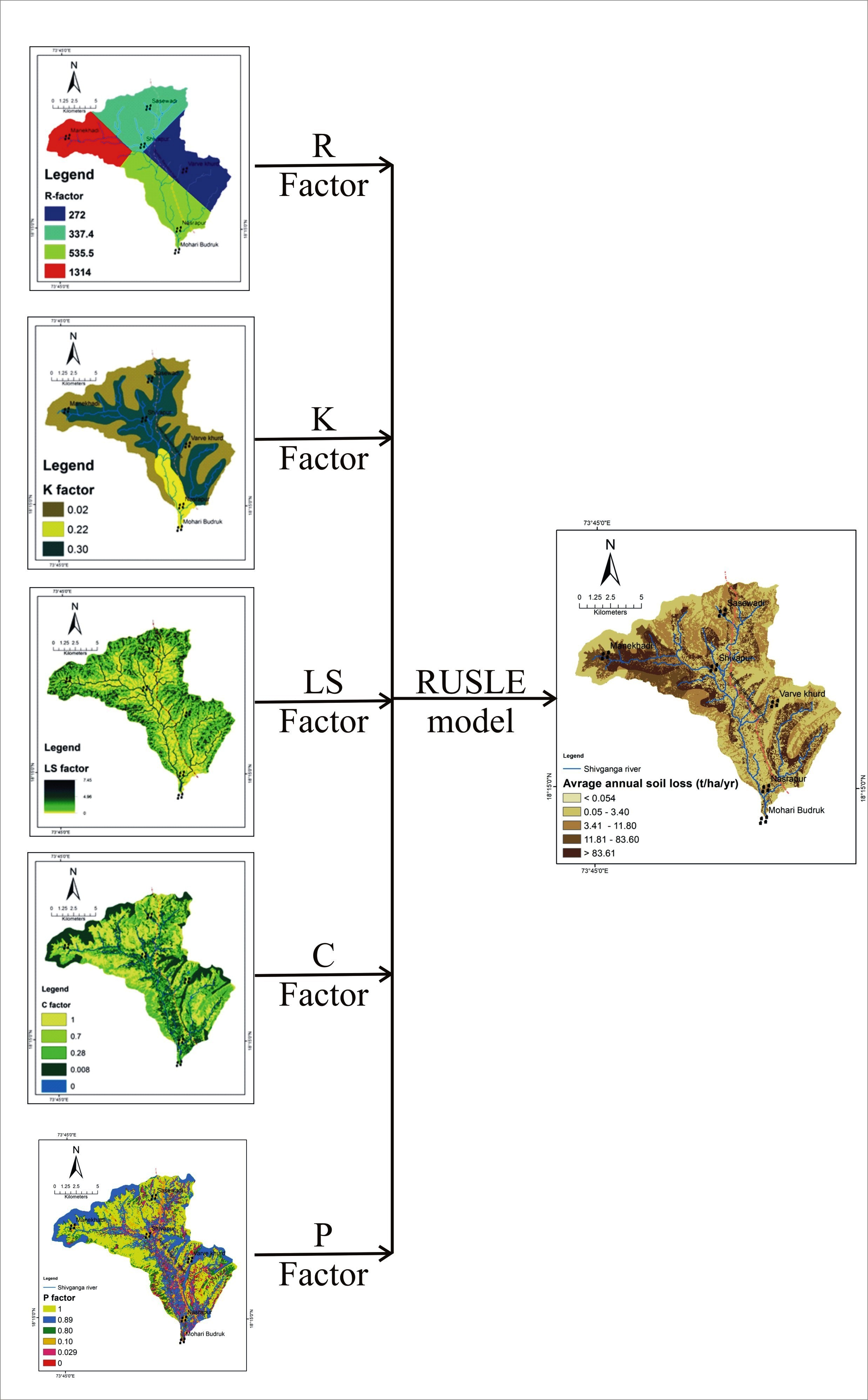
RUSLE is used to estimate soil loss from agricultural and semi-urbanized mountainous watershed.
Remote sensing data such TRMM based rainfall, DEM, Satellite Image helped to identify more fine soil loss.
GIS environment helps to integrate, evaluate and map the potential annual soil loss.
The study highlights the importance of remote sensing data in soil loss analysis.
RUSLE is very subtle to analysis the soil loss in mountainous terrain and climatic parameters like rainfall.
Arnoldus, H. M. J., 1980. An approximation of the rainfall factor in the Universal Soil Loss Equation. In: De Boodt, M., Gabriels, D. (Eds.), Assessment of Erosion. Wiley, Chichester, UK, 127-132.
Bagyaraj, M. and Gurugnanam, B., 2011. Significance of Morphometry Studies, Soil Characteristics, Erosion Phenomena and Landform Processes Using Remote Sensing and GIS for Kodaikanal Hills, a Global Biodiversity Hotpot in Western Ghats, Dindigul District, Tamil Nadu, South India. Research Journal of Environmental and Earth Sciences, 3, (3) 221-233.
Karaburun, A., 2010. Estimation of C factor for soil erosion modeling using NDVI in Buyukcekmece watershed. Ocean Journal of Applied Sciences, 3(1), 77-85.
Renard, K., Foster, G.,Weesies, G., McCool, D. and Yoder, D., 1997. Predicting Soil Erosion by Water: a Guide to Conservation Planning with the Revised Universal Soil Loss Equation (RUSLE). US Government Printing Office, Washington, DC.
Roose, E., 1975. Erosion et ruissellement en Afrique de l'ouest: vingt années de mesures en petites parcelles experimentales.
Shin, G. J., 1999. The analysis of soil erosion analysis in watershed using GIS (Ph.D. Dissertation). Department of Civil Engineering, Gang-won National University.
Shinde, V., Tiwari, K. N. and Singh, M., 2010. Prioritization of micro watersheds on the basis of soil erosion hazard using remote sensing and geographic information system. International Journal of Water Resources and Environmental Engineering , 2(3), 130-136.
Stone, R. P., and Hilborn, D., 2000. Universal Soil Loss Equation (USLE), Ontario Ministry of Agriculture, Food and Rural Affairs Factsheet.