Article Title :
Assessment of Above Ground Biomass and Fire Risk Zonation in Selected Forest Areas of LudhiKhola Watershed Gorkha Nepal
2 (2018)
47-64
Nepal , Forest Fire Risk Zonation , APH , Crown Projection Area , valley following , region growing , Individual tree crown


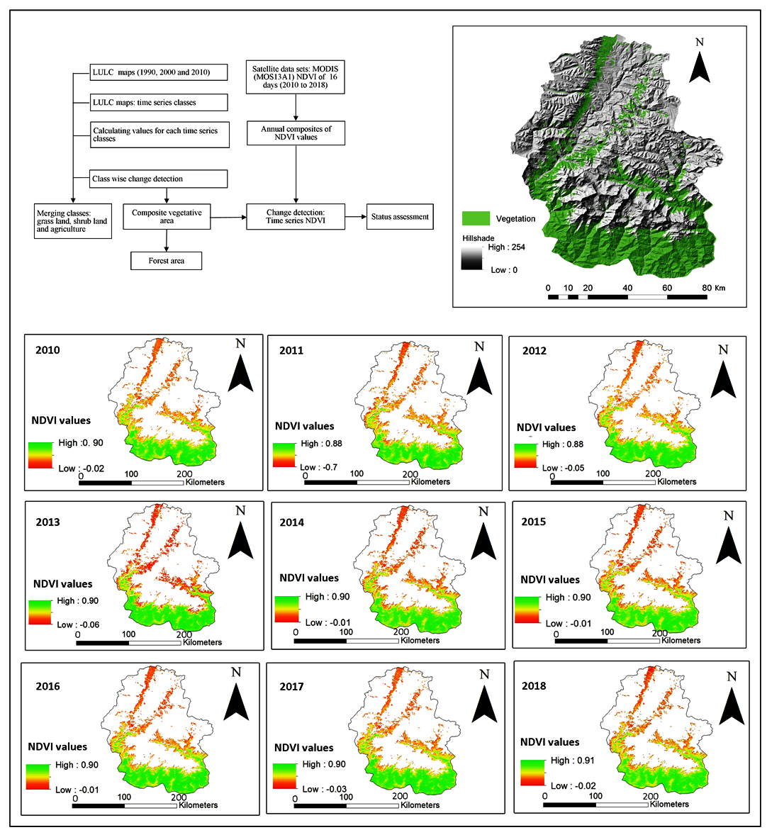
The drive for robust, accurate and cost-effective methods for biomass estimation over large areas is ever great with the launch of carbon crediting mechanisms in the developing countries such as UN-REDD [United Nations Programme on Reducing Emissions from Deforestation and Forest Degradation] and climate change mitigation program. Traditional ground based measurement requires abundant manpower, resources, cost and time. Remote sensing based technologies pertinently answer the need of time in enhancing the successful implementation of such programs. The region growing and valley following algorithm used to delineate individual tree crowns produced a segmentation accuracy of 59.35% and 54.83%, respectively. Both algorithms have similar approaches for delineation. Above ground biomass was calculated using allometric equation form and height, diameter measured from the field. Linear regression models were applied to derive the relation of biomass with crown projection area, field measured height with biomass. All models were significant at 95% confidence level and the lowest Root Mean Square Error (RMSE %) of 27.45 % (Shorea robusta) and 33.33% (others species). The total amount of biomass stocks was approximately 30620 Kg/ha-1. For forest fire hazard zonation an Analytic Hierarchy Process (AHP) method was used .The result show that 11% of the study area falls under very low fire risk zone, 55 % falls under low fire risk zone and 30 % falls under moderate fire potential zone while 4% of area falls under high forest fire risk zone. The map is also validated through major past fire incidents. The results show that the predicted fire zones are found to be in good agreement with past fire incidents, and hence, the map can be used for future forest resources management.
Biomass stock was calculated by extrapolating the biomass stock measured from plot.
The linear relationship was observed as most of the trees in the study area were young with mean DBH of 20 ± 7.5 cm and mean height of 13. ± 6.2 m.
Site specific and species specific allometric equations are essential to accurately estimate biomass of the forest.
Fire risk modeling using multi-criteria analysis and integrating different layers used for Fire Risk Hazard Zonation.
Forest area near by the settlements, open area (Shrub land) and road are more vulnerable to forest fire.
The results and methodology used in this study can be useful for application of RS and geospatial technique for estimations of above ground biomass and Fire risk zonation.
Bajracharya, K. M., 2002. Forest fire situation in Nepal. International Forest Fire News, 26: 84-86.
Chaturvedi, A. N. and Khanna, L., 1982. Forest mensuration, 9, International Book Distributors Dehra Dun, India.
Gaikwad, R. and Bhagat, V., 2017. Multi-Criteria Watershed Prioritization of Kas Basin in Maharashtra India: AHP and Influence Approaches. Hydrospatial Analysis, 1(1), 41-61.
Husch, B., Beers, T. W., and Kershaw, J. A., 2003. Forest Mensuration, 4th Edition.
IPCC [Intergovernmental Panel on Climate Change], 2003. Good practice guidance for land use, land use change and forestry. Hayama, Kanagawa, Japan.
MacDicken, K., G., 1997. A guide to monitoring carbon storage in forestry and agroforestry projects. USA, Winrock International Institute for Agricultural Development.
Mahdavi, A., Shamsi, S. R. F. and Nazari, R., 2012. Forests and rangelands’ wildfire risk zoning using GIS and AHP techniques. Casptechniques. Asp. J. Environ. Sci. 10, 43-52.
Mohammadi, F., Shabanian, N., Pourhashemi, M. and Fatehi, P., 2010. Risk zone mapping of forest fire using GIS and AHP in a part of Paveh forests. Iranian J. of Forest and Poplar Res., 18 (4), 569-586 (In Persian).
Ramanathan, R., 2001. A note on the use of the analytic hierarchy process for environmental impact assessment. J. Environ. Manag, 63, 27-35.
Sharma, E. R., and Pukkala, T., 1990. Volume Equations and Biomass Prediction of Forest Trees of Nepal. Kathmandu, Nepal: Forest Survey and Statistics Divison, MOFSC
Sharma, S. P., 2006. Participatory forest fire management: an approach. International Forest Fire News, 34:35-45.
Shelly, J. R., 2012. Woody biomass: what is it- what do we do with it? Woody biomass factsheet-WB1. Washington D.C, US.
Shrestha, B. M. and Singh, B. R., 2008. Soil and vegetation carbon pools in a mountainous watershed of Nepal. Nutrient Cycling in Agroecosystems, 81(2), 179-191.