Article Title :
Feasibility of Artificial Groundwater Recharge Structures for Urban and Rural Environment of Ranchi in India using Geospatial Technology
2 (2018)
28-42
Artificial Groundwater Recharge , GIS , RTRWH , Runoff , Mapping , Hard Rock Terrain


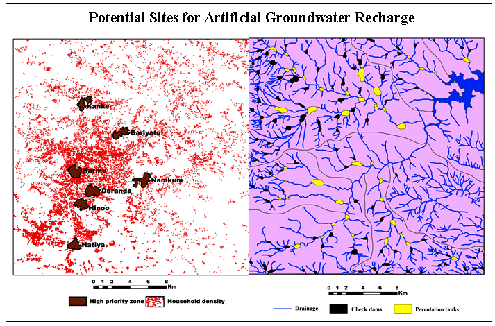
Artificial recharge plays a prominent role in the sustainable management of groundwater resources. The study has proposed a methodology to viable artificial recharge structure using geographical information system (GIS) and empirical equation techniques for augmenting groundwater resources in the Ranchi urban and rural area of Ranchi District, Jharkhand. The thematic layers for geomorphology, drainage density, order of streams, runoff and trend has been prepared in the GIS environment using convection and remote sensing data. It has been found that the slope and topographic gradient of Ranchi region is one of the major governing factors, which restricts to hold surface water stagnant. Jumar watershed is found as the most feasible watershed for the construction of check dams/percolation tanks followed by Lower Subarnarekha watershed. Out of 15 deeper exploratory wells, 14 are declining. Harmu watershed is found to be in the worst condition in terms of availability of runoff water. Harmu, Kanke, Bariyatu, Namkum, Doranda, Hinoo and Hatia have found as the most suitable locations for installation of RTRWH within the Ranchi urban area. Based on the available field information, check dams are suggested as the most promising artificial recharge structures for Ranchi rural environment.

Artificial recharge plays a prominent role in the sustainable management of groundwater resources.
The study focuses on geospatial analysis to find suitable sites for artificial recharge using GIS and empirical equation techniques.
The thematic layers for geomorphology, drainage density, order of streams, runoff and trend analysis have been used for selection of sites.
The slope and topographic gradient of Ranchi region is one of the major governing factors restricts to hold surface water stagnant.
Jumar watershed is found as the most feasible watershed for the construction of check dams/percolation.
Agarwal, A. K. and Mishra, D., 1992. Evaluation of groundwater potential in the environs of Jhansi city, Uttar Pradesh through hydrogeological assessment by satellite remote sensing technique. J. Remote Sensing, 20, 2-13.
Agarwal, A. K., Mohan, R. and Yadav, S. K. S., 2004. An integrated approach of remote sensing, GIS and geophysical techniques for hydrological studies in Rajpura block, Budaun district, Uttar Pradesh. Indian J PRVD, Jan-Feb., 35-40.
Anonymous, 2002. World Bank Report on Water Resources.
Bhattacharya, A. K., 2010. Artificial groundwater recharge with a special reference to India, IJRRAS, 4 (2), 214-221.
CGWB [Central Ground Water Board], 2009. Monthly report 2009, 2012, 2013. Ranchi district, Jharkhand.
CGWB [Central Ground Water Board], 2013. Monthly report, Ranchi district, Jharkhand.
CGWB [Central Ground Water Board], 2016. Project Wise Impact Assessment of Completed Demonstrative Artificial Recharge Projects of XIth Plan, Ministry of Water Resources, River Development and Ganga Rejuvenation, Government of India, Interim Report. Central Groundwater Board, New Delhi.
FDER [Florida Department of Environmental Regulation], 1988. The Florida Development Manual. A Guide to Sound Land and Water Management (Chapter 5). Tallahassee, Florida
Lambert, D., 1998. The Field Guide to Geology. Checkmark Books. 130-131.
Mati, B., De Bock, T., Malesu, M., Khaka, E., Oduor, A., Nyabenge, M., and Oduor, V., 2006. Mapping the potential of rainwater harvesting technologies in Africa. A GIS overview on development domains for the continent and ten selected countries. Technical Manual, 6, 126.
Oweis, T. Y., Prinz, D. and Hachum, A. Y., 2012. Rainwater harvesting for agriculture in the dry areas (p. 262) London, UK: CRC Press.
Ranjan A. K., Satya P., Akash A., Santosh K. V., Lakhindar Murmu and Patibandla B Sravan Kumar, 2017. Groundwater Prospect Variability Analysis with Spatio-Temporal Changes In Ranchi City, Jharkhand, India Using Geospatial Technology. Int. J. Earth Sci. and Engg., 10(03), 616-625.
Richard, H. M. 1998. Hydrologic Analysis and Design, 2nd Ed, Upper Saddle River, NJ.
Saraf, A. K and Jain, S. K., 1993. Integrated use of remote sensing and GIS methods for groundwater exploration in parts of Lalitpur District, U.P. International Conference on Hydrology and Water Resources, New Delhi, 20-22 December, 1993.
Wanielista, M. P., 1978. Stormwater Management: Quantity and Quality. Ann Arbor Science, Ann Arbor, Michigan.


