Article Title :
Multi-model and Vegetation Indices for Drought Vulnerability Assessment: A Case Study of Afar Region in Ethiopia
2 (2018)
1-14
Drought , Drought index , Normalized Difference Vegetation Index , Standardized Precipitation Index , Vegetation Condition Index , Vulnerability


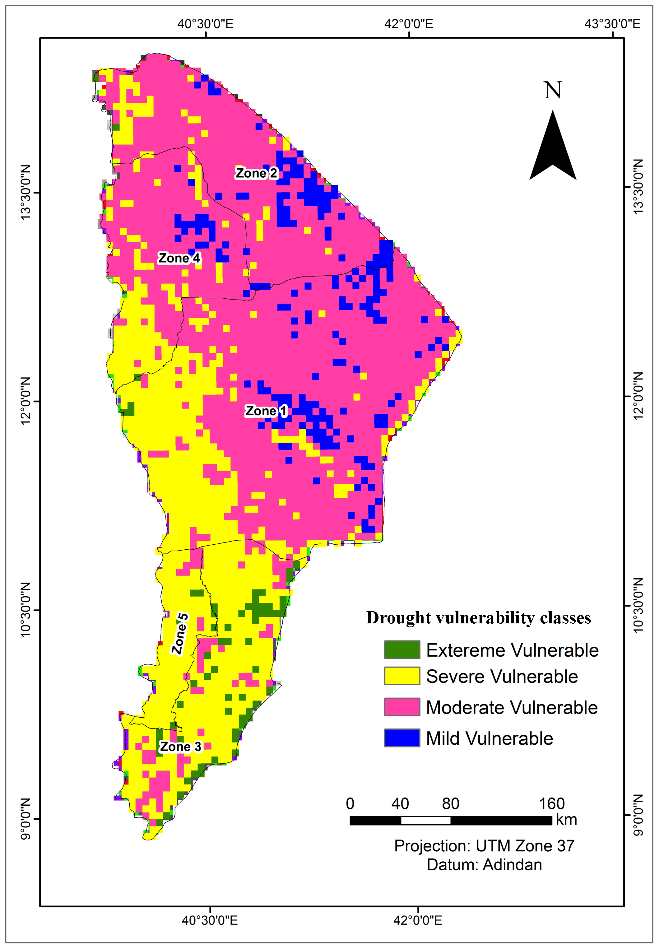
Drought is a water related climatic natural disaster affecting wide range of environmental, biological and social factors. Short, poor and delayed rainfall in 2015 caused critical water shortage, livestock causality and decline in milk production in the pastoral areas of Ethiopia. The relationship between rainfall and vegetation indices was analyzed to identify drought-vulnerable areas in Afar region of Ethiopia using 11 years time series of decadal NDVI, VCI, DSI and SPI using SPOT (2005-2013) and PROVA-V (2014-2015) data. For the validation of drought indices, correlation and regression analyses between NDVI and rainfall (r = 75%), NDVI and crop yield, and VCI and rainfall (r = 90%) were done. The findings showed that there was extreme drought in the Afar region in 2005, 2009, 2011 and 2015. The region was highly prone to drought, even though its severity levels varied in different years. Drought was severe, longer and intense in most of the areas in the region, adversely affecting agricultural productivity and livestock maintenance and management. Assessments of such natural disasters are useful to plan mitigative measures in advance for effective management programmes, including drought hazards.

This is comprehensive assessment of vegetation indices for drought vulnerability assessment of Afar Region, Ethiopia.
The final map obtained by integrating NDVI, VCI, DSI and SPI shows competent results.
Extreme droughts were observed in 2005, 2009, 2011 and 2015.
The methodology and results are competent for drought risk management and drought mitigation strategies.
Akhtar, I. H., 2014. Identification of drought events from multi years temporal SPOT NDVI data for Potohar Region in Pakistan. International Journal of Remote Sensing and GIS. 3, 39-52.
Amare, D., 2007. Application of remote sensing for delineation of drought vulnerable areas in Amhara Region, MSc thesis Addis Ababa University, Addis Ababa.
AMS [American Meteorological Society], 2004. Statement on meteorological drought. Bull. Am. Meteorol. Soc. 85, 771-773.
Anderson, J. R., Hardy, E. E., Roach, J. T. and Witmer, R. E., 1976. A land use and land cover classification system for use with remote sensor data. US Geological Survey Professional Paper, 964. 28.
ANRS., 2004. Afar ational regional state, a strategic plan for the sustainable development, conservation, and management of the woody biomass resources. Final report, Addis Ababa.
Birhanu, G., Legesse, H., Solomon, A. and Suryabhagavan, K.V., 2014. Drought risk assessment using remote sensing and GIS: The case of Southern Zone, Tigray Region, Ethiopia. Journal of Natural Sciences Research. 4, 87-94.
Chopra, P., 2006. Drought risk assessment using remote sensing and GIS: A case study of Gujarat. Thesis of Indian Institute of Remote Sensing (IIRS), Dehradun, India and International Institute for Geo-Information Science and Earth Observation, Enschede, Netherlands.
CSA, 2008. Summary and statistical report of the 2007, Population and Housing Census, Addis Ababa.
Defferew, K., 2011. The impact of drought on livelihoods, vulnerability and coping mechanisms: The case of North Shoa Zone, Oromiya, MA Thesis, Addis Ababa University, Addis Ababa.
Diress, T., Farah, K.O. and Mbuvi, D., 1998. Impacts of land use on woody vegetation in the semi-arid areas of Aba’ala district, North Afar, Ethiopia. The African pastoral forum (APF) working paper, 16, 37, Nairobi.
Dodamani, B. M., Anoop, R. and Mahajan, D.R., 2015. Agricultural drought modeling using remote sensing. International Journal of Environmental Sciences and Development. 6(5), 326-331.
Dutta, D., Kundu, A., Patel, N.R., Saha, S.K. and Siddiqui, A.R., 2015. Assessment of agricultural drought in Rajasthan (India) using remote sensing derived vegetation condition index (VCI) and Standardized Precipitation Index (SPI). The Egyptian Journal of Remote Sensing and Space Sciences, 18, 53-63.
Elagib, N. A., 2013. Meteorological drought and crop yield in Sub-Saharan Sudan. International Journal of Water Resources and Arid Environments. 2, 164-171.
Gizachew, L. and Suryabhavan, K.V., 2014. remote sensing and GIS based agricultural drought assessment in East Shewa Zone, Ethiopia. Tropical ecology. 55, 349-363.
Jeyaseelan, A. T., 2003. Droughts and floods assessment and monitoring using remote sensing and GIS. Satellite Remote Sensing and GIS applications in Agricultural Meteorology, Proceedings of a Training Workshop held 7-11 July 2003, Dehra Dun.
Kogan, F. N., 2000. Contribution of remote sensing to drought early warning. In Early Warning Systems for Drought Preparedness and Drought Management, Proceedings of an expert group meeting held on Warning Systems for Drought Preparedness and Drought Management. Lisbon, Portugal.
Lemma, G., 1996. Climate classification of Ethioia. Metorological Research Report Series, 3, 1-8, Addis Ababa.
Sara, A., 2010. Mitigating drought: Policy impact evaluation: A case of Tigray Region, Ethiopia, MSc Thesis, University of Twente, Enschede, The Netherlands.
Tadesse, T., Gabriel, B. S., Getachew, B., Teshome, R. and Shimelis, B., 2015. Evaluating a satellite-based seasonal evapotranspiration product and identifying its relationship with other satellite-derived products and crop yield: A case study for Ethiopia. International Journal of Applied Earth Observation and Geoinformation. 40, 39-54.
Vogt, J. V., Viau, A. A., Beaudin, I., Niemeyer, S. and Somma. F., 2000. Drought Monitoring from Space using Empirical indices and physical indicators in: International Symposium on satellite based Observation: A toll for the ftudy of Mediterranean Basin Tunis, Tunisia.
WMO, 2004. Satellite remote sensing and GIS applications in agricultural meteorology. Proceedings of the Training Workshop, Geneva, Switzerland, 1182, 291-313.


