Article Title :
Geospatial Suitability Mapping of Climate-based Disease Transmission using Fuzzy Logic for Central India
1 (2017)
37-45
Malaria , Transmission window , Fuzzy logic , Climate suitability , Geovisualisation


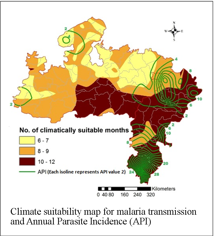
Geographic Information System (GIS) today supports health and disease mapping in diverse ways. Present study divulges geographic dimensions of malaria disease in Madhya Pradesh and Chhattisgarh states located in Central India. Chhattisgarh is second and Madhya Pradesh is the third most malarious states after Odisha in India. In the present study, an attempt is made to map climate-based malaria transmission suitability using fuzzy logic for Central India. Temperature and relative humidity were selected as the two indicators for malaria transmission suitability analysis. District wise meteorological data for 2008 was used for the present study. Monthly temperature and relative humidity interpolation maps were generated using ‘Natural Neighbor’ interpolation algorithm. For both the indicators trapezoidal membership function was selected. Arc GIS software and its FUZZY tool were used to generate ‘climate suitability map’ for malaria transmission depicting the spatial distribution of Transmission Window length (in months) across the region. The findings illustrate that most districts of Chattisgarh and very few districts of Madhya Pradesh have transmission window open for more than 10 months and are identified as ‘High Endemic Regions’. Compared to Chhattisgarh, Madhya Pradesh experiences more numbers of least suitable months i.e. February, March, April and May. The study aims to benefit judicious decision making for efficient intervention implementation.
The study aims at strengthening the spatial health decision making through climate based suitability analysis for central India composing Madhya Pradesh and Chhattisgarh states.
The fuzzy logic based climate suitability mapping methodology has efficiently identified the seasonal cycle of malaria transmission, and finally, mapped the climate suitable endemic and epidemic-prone areas in central India.
Malaria in this region is transmitted by two efficient vectors i.e. Anopheles culicifacies and An. fluviatilis.
To analyze relevance of the climate suitability with the malaria cases distributions, 2008 climate suitability map was overlain by the region’s Annual Parasite Incidence (API).
During 2008, most districts of Chattisgarh and very few districts of Madhya Pradesh have transmission window open for more than 10 months and are identified as ‘High Endemic Regions’.
Whereas, during 2008, Regions with 8-9 months of transmission windows are mostly in Madhya Pradesh, and remaining districts of Chhattisgarh, are identified as ‘Endemic Regions’.
Bush, K. F., Luber, G., Kotha, S. R., Dhaliwal, R.S., Kapil, V., Pascual, M., Brown D. G., Frumkin, H., Dhiman, R.C., Hess, J., Wilson, M. L., Balakrishnan, K., Eisenberg, J., Kaur, T., Rood, R., Batterman, S., Joseph, A., Gronlund, C. J., Agrawa, A. and Hu, H., 2011. Impacts of climate change on public health in India: future research directions. Environmental Health Perspectives, 119(6), 765-770.
Dhiman, R.C., Pahwa, S., and Dash, A.P., 2008. Climate change and malaria in India: Interplay between temperatures and mosquitoes. Regional Health Forum, 12, 27-31.
Gill, C. A., 1938. The Season Periodicity of Malaria, Churchill, London.
Russel, P. F., Luther, S. W. and Manwell, R. D., 1946. Practical Malariology, W.B. Saunders, London, 360.